Navionics
Navionics Platinum Plus Nova Scotia Land/Marine Map (msd903p2)
- SKU:
- 18805829
- MPN:
- msd903p2
- Availability:
- Out of stock
- Shipping:
- $299.00 (Fixed Shipping Cost)
- Stock Update:
- 06/15/2022 06:51:05 AM PST
- Stock Update:
- 06/15/2022 06:51:05 AM PST
Description
This item is brand-new, factory sealed.
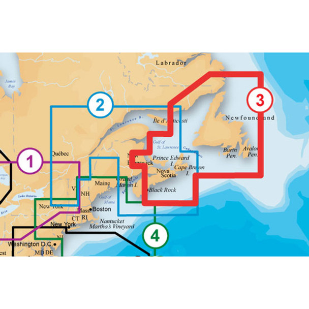
Navionics Platinum Plus 903P-2 Nova Scotia to Newfoundland Marine Charts on SD/MSD- Max detailed charts for cruising, fishing and sailing, plus 3D View, satellite overlay and panoramic port photos all in one.
- Includes SonarChartTM 1 foot HD bathymetry map that reflects ever-changing conditions, and Community Edits, valuable local information added by millions of Navionics Boating app users
- Get the most current charts every day with daily updates for one year.
- Coverage area includes marine charts from Gulf of St. Lawrence, to Newfoundland, including Cape Breton Island, Iles De La Madeleine, Prince Edward Island and Strait of Belle Isle.
Platinum Plus provides the most content so you can take full advantage of your chartplotters functionality. Dynamic 3D View allows you to customize exaggeration of key features and adjust pitch to highlight subtle depth changes or better visualize your approach through shallow or narrow channels. Satellite overlay is extremely helpful for improving situational awareness, especially in congested ports and marinas. Find hidden features such as backwater channels that might hold fish. Panoramic port photos let you head into new ports with the confidence of a local with a clear view of marina entrances, dock layouts, and more. View detailed shorelines with marinas, docks and boat ramp locations. Increase your awareness of shallow waters and hazardous areas at any depth level. Consult tides and currents. Fish smarter with up to 1 foot HD contours, you will find the best fishing spots such as wrecks, reefs and fish attractors. Enhance your favorite areas. SonarChartTM becomes more precise every day with sonar logs contributed by the Navionics Community from all major plotter/sounder brands and mobile devices. And with SonarCharTM Live, you can use your plotter/sounder to create real time personal HD bathymetry maps and upload sonar logs to Navionics. Keep your GPS charts up to date with around 2,000 edits per day. You willl have the latest Nautical Chart, Sonar ChartTM and Community Edits enriched with information from official sources, our own surveys and research, and contributions from fellow boaters. Additional features including Plotter Sync, Dock to dock Autorouting, SonarChart Live display on plotter and Advanced Map Options are available with select Raymarine models. Nautical Chart and SonarChartTM are preloaded and ready to use. Download Community Edits along with daily updates for one year.
Features
Navionics Freshest Data:
When you buy Hotmaps Premium, Hotmaps Platinum, Fish'N Chip, Gold or Platinum+ products you are eligible for unlimited updates of the 2D Gold component for a period of one year - this means you always have access to our Freshest Data.
Navionics PC App:
- Enjoy the same functionality and value of our award winning mobile apps on your PC Anytime, Anywhere. Free with the purchase of any HotMaps Premium, Hotmaps Platinum, Gold or Platinum+ chart.
- Platinum+ Multi-Dimensional Charts, with the most advanced technology and best imaging available, provide high-resolution photo/chart overlay, full-view XGA panoramic pictures, improved 3D view, complete geo-referenced coast pilots and FREE Fish'N Chip high-definition fishing detail all on the same chip.
Nova Scotia-Newfoundland:
Gulf of ST. Lawrence, Newfoundland. Including Cape Breton Island, Iles De La Madeleine, Prince Edward Island and Strait of Belle Isle.
Compatibility:
Geonav:
- G12
- GIS12
- G10
- GIS10
Humminbird:
- 1198c SI
- 11971
- 1158c
- 1157
- 1155
- 998c SI
- 998
- 997
- 967
- 958c
- 958
- 957
- 955
- 898c SI
- 898
- 858c
- 858
Lowrance:
- HDS 10
- HDS 8
- HDS 7
- HDS 5
- HDS 5Baja
Northstar:
- 6100i
Raymarine:
G-Series:
- G120
- G150
- G170,
- G190,
- GPM400
- E120
- E80
- E140W
- E120W
- E90W
- C140W
- C120W
- C90W
- 70
- 57
- 50
Simrad:
- NSE12
- NSE8
- NSO15
- NSS7
- NSS8
- NSS12
B&G:
- Zeus 8
- Zeus 12
Specs
| General Information | |
| Brand Name | Navionics |
| Manufacturer Website Address | http://www.navionics.com |
| Marketing Information | Multi-dimensional marine charts that offer navigators and fishermen a selection of bonus information beyond the best available navigation charts such as panoramic pictures, 3D/2D views with satellite imagery, coast pilot guides, POIs & built-in offshore fishing detail. |
| Product Type | Land/Marine Map |
| Product Name | Platinum Plus Nova Scotia Land/Marine Map |
| Manufacturer | Navionics, Spa |
| Manufacturer Part Number | MSD/903P-2 |
| Product Model | MSD/903P-2 |
| Product Line | Platinum Plus |
| Product Information | |
| Continent | South America |
| State/Province/Territory |
|
| Marine | Gulf of Saint Lawrence |
| Application/Usage | Fishing |
| Country | Canada |
| Distribution Medium Type | SD |
Warranty Information


